


ELIZABETHTOWN — Hurricane Florence is expected to impact Bladen County later this week.
The storm regained hurricane status Sunday and is poised for landfall sometime Thursday or Friday between Charleston, South Carolina, and Norfolk,Virginia. Forecasters are still waiting for a development sometime Tuesday to make the final determination.
Thoughout Sunday and into Monday, Wilmington was deemed central to landfall probability.
The National Hurricane Center said Monday that Thursday is the most likely day for arrival on the coast, and it expects the storm to be either Category 3 or 4. Heavy rain could continue into the weekend, and some forecasts are calling for it to stall out — meaning more rain for a longer period of time.
Only three hurricanes of Category 4 status have landed north of the Georgia border — Hugo in 1989, Gracie in 1959 and Hazel in 1954.
Steering the hurricane, and therefore its impact on Bladen County, is the strength and westward extent of a dome of high pressure that was expected to develop north of Florence in the western Atlantic Ocean on Monday and Tuesday. The strength of this ridge will push the hurricane westward, and determine its landfall location.
While Charleston to Norfolk was the forecast cone of probability on Monday morning, forecasters were saying then that residents in Georgia and north Florida needed to monitor developments. The area north of Norfolk in the mid-Atlantic was also advised to be alert.
Rip current warnings extended from Daytona Beach, Florida, to Long Island, New York, for Wednesday morning.
Major inland flooding was predicted in an area that includes Bladen County and most of central and eastern North Carolina. Even more was predicted near Charlotte and in areas of the Piedmont.
The storm could dump a foot or two of rain in places, forecasters said.
The University of North Carolina at Wilmington canceled classes for the week, advising students to go to a safer location. An alumni weekend celebration was scrubbed.
An earlier prediction, last week, of Florence making a turn northward and missing the U.S. has been dismissed.
“All indications are that Florence will be an extremely dangerous Category 4 hurricane while it moves over the western Atlantic toward the southeastern United States,” the hurricane center said in a statement.
Florence is a name that has been used for hurricanes since 1953. Names are retired from future use based on destruction; already another forecast is that this will be the last Florence.
Further out to sea, Hurricane Isaac became the fifth named hurricane of the 2018 Atlantic season. It has not yet been deemed a threat to land.
Category 4 has wind speed of 130 mph or more, with potential for catastrophic damage.
Gov. Roy Cooper, as well as the governors in South Carolina and Virginia, declared a state of emergency. Navy ships in Virginia’s Hampton Roads area will leave port for their safety.
Cooper’s statement said residents both coastal and inland need to be ready for heavy rainfall and flooding.
“Review your emergency plans and gather your supplies now,” Cooper said.
Mike Sprayberry, the state’s emergency management director, said his office is monitoring updates from the National Hurricane Center and the Federal Emergency Management Agency. He advised residents to make plans, have supply kits, prepare their homes and know their evacuation routes.
Cooper’s office said Department of Transportation workers are getting response equipment ready, such as bulldozers and chainsaws.
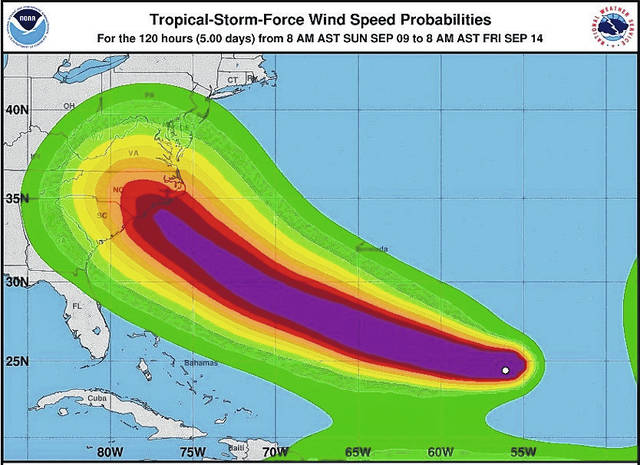
The strength of winds associated with Hurricane Florence and the projected path between Sunday morning and Friday morning, a 120-hour period, is reflected in this image. Florence is expected to make landfall on the southeastern U.S. coast late this week.

Alvin Shephard examines one of the last packages of bread in the Elizabethtown Food Lion on Sunday. All of the loaves were gone, and the only thing remaining were hamburger and hot dog buns.
The bread aisle in the Food Lion in Elizabethtown had been picked clean ahead Sunday afternoon. Hurricane Florence, at the time, was lurching toward the southeastern United States without a definitive landing spot, though most forecasts had it pegged between Charleston, South Carolina, and Norfolk, Virginia.