


ELIZABETHTOWN — Hurricane Florence approached the coast and Bladen County remained prepared and using ample caution late Wednesday night.
The 11 p.m. statement from the National Weather Service said the county is under a tropial storm warning, meaning sustained winds of 39 mph or higher, and also a hurricane watch, meaning hurricane force winds that are sustained at 74 mph or higher.
The NWS said 10 million people live in areas with hurricane watches or warnings and tropical storm watches and warnings.
Florence went from Category 3 to 2 between 8 and 11 p.m. Wednesday evening. Wind shear and a low pressure near Florida were part of the equation in that change, but winds remained sustained at 110 mph and the width of the storm includes tropical storm-force winds extending 195 miles from its center. Hurricane-force winds extend 70 miles from the center. Florence will have a final chance to strengthen as it passes over the Gulf Stream.
The storm was measured at about 500 miles wide earlier in the day, meaning about twice the vertical size of North Carolina along the Interstate 95 corridor.
The updated forecast track takes the storm’s eye south of Bladen County, but it will be slow moving and dumping large amounts of rain. A rainfall estimate map released late Wednesday afternoon placed the county in a split range that was 15-20 inches and 20-plus inches.
Flood stage for the Cape Fear River in Elizabethtown is 25 feet. A measurement from the Advanced Hydrologic Prediction Service of the NWS was not available. At the northern tip of the county at 10 p.m., the Cape Fear measured 34.75 feet at the W.O. Huske Lock; flood stage there is 42 feet. It measured just under 34 feet Sunday night at 11 p.m.
If the storm moves according to this latest track, it would be just inland near Wilmington on Friday morning at 8 a.m. and 24 hours later would still be centered just inside the state line headed southwest toward central South Carolina. It would be more centrally in South Carolina on Saturday night at 8 p.m., about to move northwest toward Clemson and then on into Kentucky.
The predictions for power outages being “likely” overnight Thursday into the days on Friday and Saturday extended from Robeson County to Wayne County and southeastern all the way to the coastline. More widespread outages were predicted between Wilmington and Atlantic Beach, particularly in Onslow County, where Marines at Camp Lejeune evacuated to Georgia.
Duke Energy, the nation’s second largest power company, said Florence could knock out power to three-fourths of its 4 million customers in the Carolinas. The outage could last, it said, for weeks. Crews from as far away as Manitoba, Canada, were on the way, WRAL reported.
Wednesday at noon, shelters opened at Bladen Lakes Primary School, East Arcadia School, East Bladen High School and West Bladen High School. More than 200 people were checked in within hours of their opening.
Bradley Kinlaw, director of Emergency Management for the county, reminded anyone coming that no reservations are taken and not everything can be provided to those that come. A list is posted of what to bring and includes items such as medicines, bottled water, food, toiletries, clothes for two to three days, air mattress or sleeping bag, and important documents.
Elizabethtown called an emergency meeting for Thursday morning to amend the state of emergency declaration.
Bladenboro officials issued a voluntary evacuation notice.
BARTS, the county’s public transportation system, was ferrying residents to shelters. Call 910-862-6930. Once winds reach 25 mph, the service is expected to shut down for safety reasons.
Classes ended for the week in Bladen County Schools on Tuesday; Bladen Community College shut down operations Wednesday afternoon. The 26th annual Dublin Peanut Festival, scheduled for Saturday, was called off.
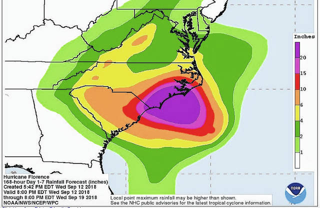
Southeastern North Carolina is forecast to get more than 20 inches of rainfall from Hurricane Florence.

Phoebe Tesh takes a break from packing to evacuate from Wrightsville Beach on Wednesday as Hurricane Florence threatens the coast.

A sign posts a mandatory evacuation prior to Hurricane Florence in Emerald Isle on Wednesday.

This enhanced satellite image made available by NOAA shows Hurricane Florence off the eastern coast of the United States on Wednesday at 5:52 p.m. EDT.
The track for Hurricane Florence, as forecast at 11 p.m. Wednesday, carried the center just south of Bladen County. Widespread rain and flooding is expected.