
ELIZABETHTOWN — Power has been lost at all five schools serving as shelters for Hurricane Florence in Bladen County, and the number of roads closed due to downed trees numbers more than a dozen including major arteries N.C. 87 East and U.S. 701 North.
Bradley Kinlaw, director of Emergency Management for the county, said the peak of the storm was still expected about 2 p.m. Friday and urged residents to stay off the roads. EMS crews had been grounded pending an OK by Kinlaw, and fire departments throughout the county were scaling back due to mobility and for safety.
At noon, the wobbly center of Florence was about 25 miles southwest of Wilmington with wind down to 80 mph. Hurricane force winds still extended 70 miles from the center, and tropical storm force winds reached out 195 miles.
“We’re still getting more trees and power lines down,” Kinlaw said just past noon. “Our shelters have lost capabilities, so we’re working operations to ensure our food supply is up.”
More than 1,000 had sought shelter at Bladen Lakes Primary School, Elizabethtown Middle, East Arcadia School and East and West Bladen high schools. West Bladen reached capacity sans people with special needs or bringing pets on Thursday.
Bladen County is under curfew 8 p.m. to 7 a.m. until further notice.
Kinlaw said he was not aware of any life-threatening rescues thus far. Swift water rescue teams from Vermont were stationed in Bladenboro, a community where flooding can occur, and in Kelly.
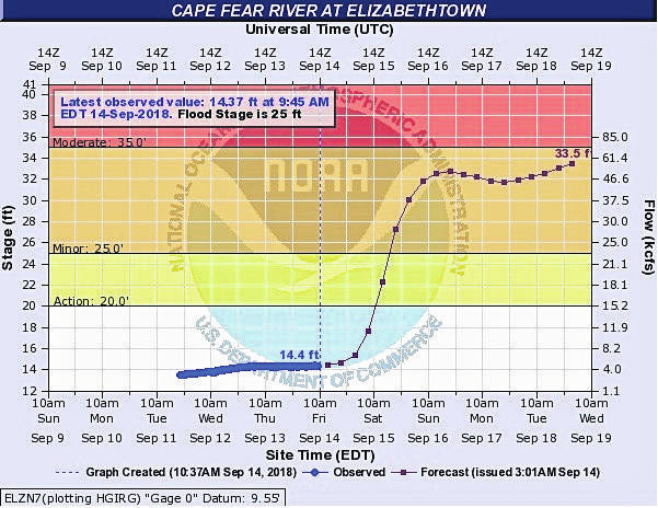
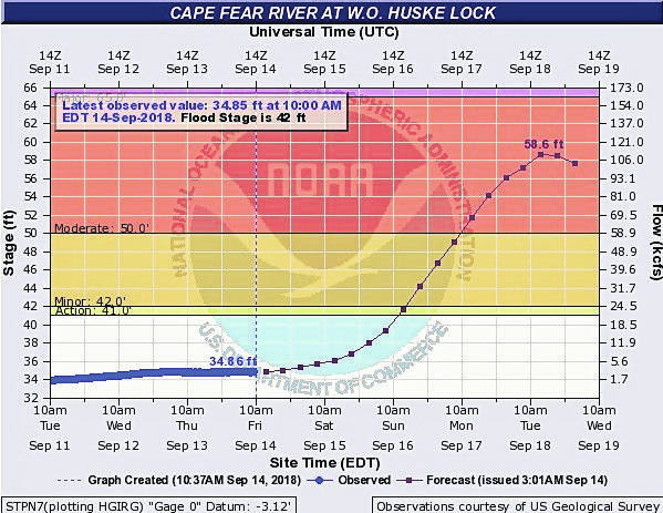
The forecast called for 30 inches of rain in the Riegelwood area and 26 inches in Elizabethtown. The Cape Fear River is forecast to hit flood stage on Sunday morning about dawn at both the Huske and Elizabethtown measuring stations.
According to the forecast river levels from the National Weather Service, each point will be close to or exceeding levels seen when Hurricane Matthew devastated the county in October 2016.
“Everybody stay off the roads,” was Kinlaw’s message to the county.
Florence made landfall Friday morning about 7:15 near Wrightsville Beach. Winds were at 90 mph with the Category 1 storm, which had peaked at Category 4 with 140 mph winds earlier in the week.
Some of the storm’s worst damage was from rain north of the eyewall. Emerald Isle recorded 6.3 feet of inundation early Friday, and the city of New Bern had standing water 10 feet deep on city streets. WCTI had to evacuate its television studio late Thursday and into early Friday because of rising water.
Oriental, in Pamlico County, picked up 18 inches of rain in a matter of hours.
There were 9,700 National Guard troops and civilians deployed with high-water vehicles, helicopters and boats throughout eastern and southeastern North Carolina.
President Donald Trump, early Friday, tweeted “Incredible job being done by FEMA, First Reponders, Law Enforcement and all. Thank you!”
The storm is expected to remain in southeastern North Carolina most of the day, gradually creep into northeastern South Carolina, and eventually move west and swing up the Appalachian Mountains.
The Cape Fear River is expected to reach flood stage on Sunday morning, with the highest levels coming between Monday and Wednesday.
At the W.O. Huske Lock by the Cumberland County line, the river was 34.98 feet Friday about noon. Flood stage is 42 feet and the forecast called for a level of 43.4 feet at 6 a.m. Sunday.
It is expected to crest near 65 feet Monday night into Tuesday.
The record crest at the Huske station is 75.5 feet, set Sept. 22, 1945. The second-highest happened after Hurricane Matthew, hitting 68.46 feet on Oct. 10, 2016.
The Elizabethtown reporting station was at 14.35 feet Friday morning about 11:45 a.m. Flood stage there is 25 feet and the forecast called for a level of 27.7 feet by 6 a.m. Sunday.
Forecast data goes into Wednesday, when the river would still be climbing to more than 36 feet.
The record crest at the Elizabethtown station is 43.20 feet, set Sept. 23, 1945. The second-highest is 39.10 feet on Sept. 23, 1928. After Matthew, the river crested at 35.44 feet on Oct. 11, 2016, the fourth-highest on record.

This satellite image provided by NOAA shows Hurricane Florence on the eastern coast of the United States on Friday just before landfall.
Leave a Reply