
ELIZABETHTOWN — While Hurricane Ian continues its march north along the East Coast, Bladen County residents and National Weather Service forecasters are preparing for the storm’s arrival here.
On Thursday afternoon, the National Weather Service issued a series of watches and warnings related to Ian’s eventual arrival in and around Bladen County.
Changes on Thursday included the following, related to the greater Bladen County area:
– A Tropical Storm Warning has been issued for Bladen, Columbus, Inland Brunswick, Inland New Hanover, Inland Pender, and Robeson counties.
– The Tropical Storm Warning has been upgraded to a Hurricane Warning and the Storm Surge Watch has been upgraded to a Storm Surge Warning for Coastal Georgetown and Coastal Horry County, South Carolina.
– The Tropical Storm Warning has been upgraded to a Hurricane Warning for Central Horry, Inland Georgetown, and Northern Horry
– The Tropical Storm Watch has been upgraded to a Hurricane Warning for Williamsburg
– The Tropical Storm Watch has been upgraded to a Tropical Storm Warning for Darlington, Dillon, Florence, Marion and Marlboro counties.
– A Storm Surge Watch has been issued for Coastal Brunswick, Coastal New Hanover, and Coastal Pender
The storm was expected to come ashore in the Charleston, South Carolina area and move north toward Bladen County, bringing heavy rain, strong wind and wind gusts, as well as flooding in low-lying areas.
The strongest winds were expected to arrive early Friday morning with sustained winds of at least 30 miles per hour and as high as 70 miles per hour, according to the National Hurricane Center.
Accompanying the wind, residents should expect power outages throughout the county.
Duke Energy, which provides power to most of the region, has an interactive outage map at https://outagemap.duke-energy.com/#/current-outages/ncsc, where residents can see reported power outages.
The National Weather Service said residents can prepare for tropical weather winds, which could bring damage in the form of the following:
WIND
– Damage to roofing and siding, along with damage to porches and awnings. A few buildings experiencing window, door and garage door failures.
– Damage to vulnerable structures such as carports, sheds and mobile homes is possible.
– Large limbs will be down with several trees snapped or uprooted. Several fences and roadway signs may become blown over. Some roads may become impassable due to large debris blocking the roadway, especially within urban or heavily wooded locations.
– Some bridges, causeways, and elevated roads may be impacted by high winds making driving on them hazardous.
Scattered power and communications outages are possible, but more prevalent in areas with above ground lines.
Also, protect against hazardous wind having possible limited impacts across inland South Carolina and southeast North Carolina.
FLOODING
In regard to flooding, The National Weather Service has issued a weather statement to help protect against life-threatening rainfall flooding. Potential impacts include:
– Major flooding from rainfall may prompt evacuations and numerous rescues.
– Rivers and streams may rapidly overflow their banks in multiple places. Creeks and ditches will flood and may contain strong currents.
– Flood waters may enter many structures, and some may become uninhabitable.
– Some road scours or complete road failures will be possible, along with the potential for sinkholes.
– Many streets and parking lots may flood, and may be impacted by flowing water. Many road and low-lying bridge closures are possible with some weakened or washed away.
– Driving conditions will be dangerous.The delivery of drinking water and sewer services may be interrupted.
– Flood waters may be polluted and contain hazardous materials.
TORNADOES
The National Weather Service also said Tornadoes may accompany the storm when it arrives on Friday.
“Protect against a tornado event having possible limited impacts across southeast North Carolina and northeast South Carolina,” according to the weather statement released Thursday afternoon.
Potential impacts include:
– The occurrence of isolated tornadoes can hinder the execution of emergency plans during tropical events.
– A few places may experience tornado damage, along with power and communications disruptions.
– Tornadoes can cause damage to trees, vehicles, boats and buildings. Unsecured mobile homes and poorly constructed structures are particularly vulnerable.
STORM IMPACT
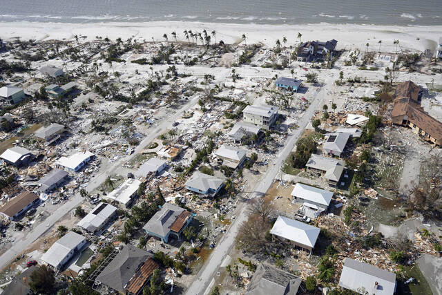
Rescue crews waded through flooded streets and used boats Thursday in a scramble to save people trapped after Hurricane Ian destroyed a cross-section of Florida and brought torrential rains that continued to fall.
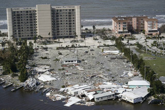
The destruction began to come into focus a day after Ian made landfall in Florida as one of the strongest hurricanes ever to hit to the U.S. The storm flooded homes on both of the state’s coasts, cut off the only bridge to a barrier island, destroyed a historic waterfront pier and knocked out electricity to 2.5 million Florida homes and businesses. At least one man was confirmed dead.
“We’ve never seen storm surge of this magnitude,” Florida Gov. Ron DeSantis told a news conference. “The amount of water that’s been rising, and will likely continue to rise today even as the storm is passing, is basically a 500-year flooding event.”
Though downgraded to a tropical storm by Thursday morning, the National Hurricane Center said storm surge and flooding rains remained a threat as Ian crept across the Florida peninsula and emerged in the Atlantic Ocean. Forecasters predicted a northward turn toward South Carolina, and a hurricane warning was issued for the state’s coastline.
Sheriffs in southwest Florida said 911 centers were inundated by thousands of stranded callers, some with life-threatening emergencies. The U.S. Coast Guard began rescue efforts around daybreak on barrier islands near where the Ian struck, DeSantis said. Fire departments fanned out in flooded areas as well.
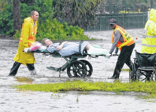
In the Orlando area, Orange County firefighters used boats to reach people in a flooded neighborhood. A photo the department posted on Twitter showed one firefighter carrying someone in his arms through knee-deep water. At an area nursing home surrounded by water, patients were carried on stretchers across floodwaters to a waiting bus.
In Fort Myers, a few miles west of the barrier island where Ian came ashore, Valerie Bartley’s family spent desperate hours Wednesday holding a dining room table against their patio door, fearing the storm raging outside “was tearing our house apart.”
“I was terrified,” Bartley said. “What we heard was the shingles and debris from everything in the neighborhood hitting our house.”
She said her 4-year-old daughter grabbed her hand and said: “I’m scared too, but it’s going to be OK.” The girl was right. The storm ripped away patio screens and snapped a palm tree in the yard, Bartley said, but left the roof intact and her family unharmed.
Authorities confirmed at least one Florida death — a 72-year-old man in Deltona who fell into a canal while using a hose to drain his pool in the heavy rain, the Volusia County Sheriff’s Office said. Two other storm deaths were reported in Cuba after Ian struck the island nation earlier.
Lee County Sheriff Carmine Marceno said his office was scrambling to respond to thousands of 911 calls, but many roads and bridges in Fort Myers and the surrounding area remain impassable.
“It crushed us.” Marceno told ABC’s “Good Morning America.” “We still cannot access many of the people that are in need.”
Emergency crews sawed through toppled trees to reach stranded people. Many in the hardest-hit areas were unable to call for help amid widespread electrical and cellular outages.
“Portable towers are on the way for cell service. Chances are your loved ones do not have ability to contact you,” said the sheriff’s office in Collier County, which includes Naples. “We can tell you as daylight reveals the aftermath, it’s going to be a hard day.”
A chunk of the Sanibel Causeway fell into the sea, cutting off access to the barrier island where 6,300 people normally live. It was unknown how many had heeded orders to evacuate, but Charlotte County Emergency Management Director Patrick Fuller expressed cautious optimism that worst-case scenarios might not have been realized.
No deaths or injuries have been confirmed in the county, and flyovers of barrier islands show “the integrity of the homes is far better than we anticipated,” Fuller said.
South of Sanibel Island, the historic beachfront pier in Naples got destroyed, with even the pilings underneath torn out, as towering waves crashed over the structure. “Right now, there is no pier,” said Penny Taylor, a Collier County commissioner.
In Port Charlotte, a hospital’s emergency room flooded and fierce winds ripped away part of the roof, sending water gushing down into the intensive care unit. The sickest patients — some on ventilators — were crowded into the middle two floors as the staff prepared for storm victims to arrive, said Dr. Birgit Bodine of HCA Florida Fawcett Hospital.
The Florida Highway Patrol shut down the Florida Turnpike in the Orlando area and said the main artery in the middle of the state will remain closed until water subsides.
Ian struck Florida as a monstrous Category 4 storm, with 150 mph (241 kph) winds that tied it for the fifth-strongest hurricane ever to hit the U.S.
Even after weakening, Ian’s tropical-storm force winds still reached 415 miles (667 kilometers) from its center. The hurricane center warned storm surge of 6 feet (1.83 meters) or more was possible from Daytona Beach, Florida, to north of Charleston, South Carolina. And rainfall of up to 8 inches (20.32 centimeters) threatened flooding in the Carolinas and Virginia.
“It doesn’t matter what the intensity of the storm is. We’re still expecting quite a bit of rainfall,” Robbie Berg, senior hurricane specialist with the National Hurricane Center, said in an interview with The Associated Press.
The U.S. Coast Guard initiated a search and rescue mission for 23 people after a boat carrying Cuban migrants sank Wednesday in stormy weather east of Key West. It found three survivors, and four others swam to shore, the U.S. Border Patrol said. Air crews continued to search for possibly 20 remaining migrants.
Leave a Reply